| Hydro
|

|
| Temel Bilgiler
|
| Harita türü: |
Bölgesel Kontrol
|
| Dosya adı: |
tc_hydro
|
| Yayımlanma: |
10 Ekim 2007
(Başlat)
|
| Yapımcı(lar): |
Valve
|
| Harita Bilgisi
|
| Çevre: |
Endüstriyel Çevre
|
| Ortam: |
Güneşli
|
| Çevresel etkenler: |
Çukurlar
|
| Harita Eşyaları
|
 Sağlık Paketleri: Sağlık Paketleri:
|
 ×13 • ×13 •  ×12 ×12
|
 Cephane Kutuları: Cephane Kutuları:
|
 ×20 • ×20 •  ×11 • ×11 •
 ×6 ×6
|
| Harita Fotoğrafları
|
|
|
| Harita Genel Bakışı
|
|
|
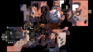
Hydro, bir Bölgesel Kontrol haritasıdır ve oyunla beraber yayınlanan ilk altı haritadan biridir. Hydro haritası şimdiye kadarki tek resmî bölgesel kontrol haritasıdır. Bunun nedeni muhtemelen bu tarzda bir haritanın tasarlanmasının çok karmaşık ve zor olmasıdır.
Hydro haritasındaki amaç "bölgeleri" ele geçirerek tüm haritaya sahip olmaktır. Her oyun, takımlar kendi noktalarını korurken diğer takımın o noktayı ele geçirmeye çalıştığı "noktadan noktaya" tarzındaki altı mevcut bölgeden rastgele başlar. Bir takım, düşman takımın kontrol noktasını başarılı bir şekilde ele geçirdikten sonra, bir sonraki raunt haritanın rastgele farklı bir noktasında başlar. Bir takım dört bölgeyi de ele geçirdikten sonra, saldırmakta olan takım düşman takımın üssünü ele geçirmelidir. Bu arada, diğerleri de kendi hayatları pahasına üssü savunmalıdır. Eğer üssün kontrol noktası ele geçirilirse, saldırmakta olan takım raundu kazanır. Bir sonraki raunt başladığında, bölgeler sıfırlanır ve rastgele yeni bir oyun seçilir.
Tanıtım Videosu
Haritadaki Yerler
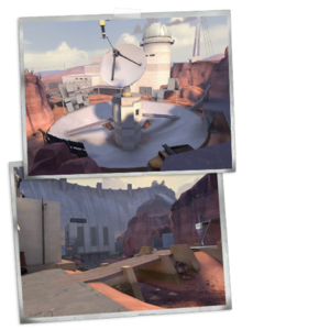
RED CP1: The Radar Dish

The Radar Dish capture point.
A large radar dish. The capture point is located in the center.
- Entrances from the flood area: The radar dish is connected to the flooded area of the map via a pair of ground level tunnels.
- Entrances from the turbine room: The turbine room is connected to the radar dish by a large suspended rock formation. This formation is split into two paths with a hole in the middle, the paths splitting left and right at the radar dish end, and connecting to the turbine room at the other end.
- Entrances from the bridge area: There are three paths from the radar dish to the bridge area. The first is the large path on the right hand side of the map. The other two paths are to the left of the main path, one of which goes off to the left (either down to the ground or onto a catwalk), while the middle one connects directly to the raised rocky ledge of the bridge area.
- Under the stairs: All of the stairs in the radar dish area can be shot through, and are a common place for Sentry Guns.
BLU CP1: The Power Plant

The Power Plant capture point.
The turbine room capture point is located on a metal bridge suspended in the middle of the building.
- Entrances from the flood area: The flood area connects to the turbine room via three paths. The two left paths connect to an open area outside of the turbine room, which in turn allows access to either the lower area of the building, or the room with the large pipes. The third path is on the right, and goes from the flooded area through a small tunnel and meets with the lower left path.
- Entrances from the bridge area: The turbine room is connected to the bridge area by a main road, sewer tunnels, and the ventilation system. The main road leads to an area outside of the turbine room that allows access either to the lower or middle levels of the building. The sewers connect the bridge area to the lower area of the turbine building, while the vents connect the roof of the bridge area to the room full of pipes next to the main building.
- Entrances from the radar dish: The radar dish connects to the turbine room via a rock formation. Once inside the building, the exits lead either onto the cat walk, or follow the stairs down to the middle of the room.
- Service room: There is a small windowed room that is next to the bridge. This room is often used as a hiding place for Engineers as it allows them to see attackers without being shot at.
RED CP2: The Dam
The flood area control point is located on top of a raised concrete block in the middle of a large open area with standing water.
- Entrances from the bridge area: The bridge area connects to the flood area via an upper and lower path. Both paths converge in a cavern that then splits into an upper, lower, and sewer path. The upper path connects to the ledge overlooking the bridge. The lower path follows the water along the ground under the ledge. The sewer path exits in front of a truck just next to the bridge.
- Entrances from the radar dish: The flood area is connected to the radar dish by a pair of small tunnels. One tunnel comes out near the flood area spawn room, while the other comes out behind the flood area point.
- Entrances from the turbine room: The turbine room connects to the flood area via three paths. One path leads from the ground level and to the right, and eventually connects to the long stairs in the flood area. The second path follows the ground around to the left, and can either stay at ground level, or connect to the top of the long stairs. The final path branches off the second path, and leads down a small tunnel to the water area behind the flood area capture point.
- Second story windows: The flood area spawn room has a second floor that Snipers often use as a nest.
BLU CP2: The Warehouse

The Warehouse capture point
The bridge area control point is on a low concrete bridge outside of a large building.
- Entrances from the radar dish: The bridge area is connected to the radar dish via three paths. The main path hugs the left side of the map. The second path connects the bridge area ledge to the middle of the radar dish area, while the right path comes out on the ledge on the radar dish side.
- Entrances from the flood area: The flood area connects to the bridge area by two paths. The upper path connects exits above the flood area capture point, while the lower path comes out in the water behind the flood area capture point.
- Entrances from the turbine room: The bridge area connects to the turbine room via the road, the sewers, and the vents. The road leads to a small area that connects to the middle and lower levels of the turbine room. The sewers lead to the lower level of the turbine room, and the vents connect to the room full of pipes adjacent to the main building.
BLU ve RED Kontrol Noktaları
Strateji
Kontrol Noktaları Süreleri
| Center four control points
|
×1
|
|
| ×2
|
|
| ×3
|
|
| ×4
|
|
| Final control points
|
×1
|
|
| ×2
|
|
| ×3
|
|
| ×4
|
|
İlgili vaşarımlar
|
|
Acımasız Saldırı
Hiçbir nokta kaptırmadan Hydro'yu kazan.
|
|
|
|
Güncelleme Geçmişi
28 Eylül 2007 Yaması
- Fixed a case where players could get stuck in
tc_hydro
25 Ekim 2007 Yaması
- Fixed issues on Hydro that could occur when a server emptied in the middle of a round.
15 Kasım 2007 Yaması
- Fixed an exploit that would allow players to jump out of the map.
27 Mayıs 2010 Yaması
- Added respawn time advantages when a team begins to cap any point. Resets when the cap progress resets.
- Fixed various nobuild and playerclip issues reported by the community.
- Removed logic that reduced spawn times based on roundtime.
10 Temmuz 2013 Yaması
- Fixed clip brush exploit where players could get out of world
- Fixed players getting on top of monument.
Hatalar
- The boom barrier at the BLU Base entrance is solid when the Power Plant control point is owned by BLU, but not when it is owned by RED and the BLU Base is under attack.
Ek Bilgiler
- The Radar Dish control point is based on the Arecibo radio telescope.
- Hydro appears in Worms: Reloaded as one of the forts.
Galeri
Ayrıca Bakınız

 Genel
Genel


